Enregistrez gratuitement cette image
en 800 pixels pour usage maquette
(click droit, Enregistrer l'image sous...)
|
|
Réf : T02231
Thème :
Terre vue de l'espace - Iles - Récifs (286 images)
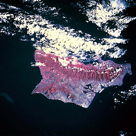
Titre : Oahu, Hawaii, U.S.A. October 1995
Description : (La description de cette image n'existe qu'en anglais)
This infrared photograph provides information about the severity of erosion on the slopes of the island’s two mountain ranges. The infrared film highlights the ruggedness of both the larger Koolau Range [3150 feet (960 meters)] on the northeast and the Waianae Range [4025 feet (1227 meters)] near the southwest coast. The infrared film also helps delineate the land-water boundaries, especially around Pearl Harbor. Easily discernible is Honolulu International Airport along the south-central coast. Large green cultivated field patterns near the northwest end of the island (shown in red) indicate healthy crops are growing on large plantations.
|
|

